The Patapsco Regional Greenway (PRG)
The Patapsco Regional Greenway (PRG) Concept Plan and Implementation Matrix identifies and prioritizes a shared-use path system along the Patapsco Valley between Sykesville and the Inner Harbor of Baltimore. This 58-mile system uses existing trails, roads and utility corridors to connect neighborhoods and destinations in Baltimore City and Baltimore, Anne Arundel, Howard and Carroll Counties. A completed greenway system will improve opportunities for alternative transportation, recreation and economic development for communities along the route. This project was led by Baltimore Metropolitan Council (BMC) and the Baltimore Regional Transportation Board’s (BRTB) Bicycle Pedestrian Advisory Group (BPAG). The Concept Plan for this project was accepted by the BRTB on November 28, 2017. Now the implementation matrix can be utilized by BRTB partners to build segments of the plan.
While most of the PRG corridor will be a greenway and linear trail within Patapsco Valley State Park (PVSP) there is potential for additional economic activity around the areas outside of the park. In Carroll County, the desire is for this regional system to connect to Sykesville’s Historic Main Street. Neighborhood connections within Sykesville to the PRG are also examined to increase activity along the proposed greenway. The PRG is ranked priority #1 for regional bike-ped projects, in the County’s Bicycle & Pedestrian Master Plan.
Sykesville to McKeldin Segment of the PRG (Carroll County)
PRELIMINARY DESIGN COMPLETED SUMMER 2022.
Carroll County is partnering with the Town of Sykesville, BMC, Maryland Department of Transportation - State Highway Administration (MDOT SHA), and PVSP on this project. Sign up for email notifications (link at the bottom of this page) for additional information and ways to participate as we move towards final design.
|
Section 1 - Western Portion: Main Street Sykesville to Freedom Park
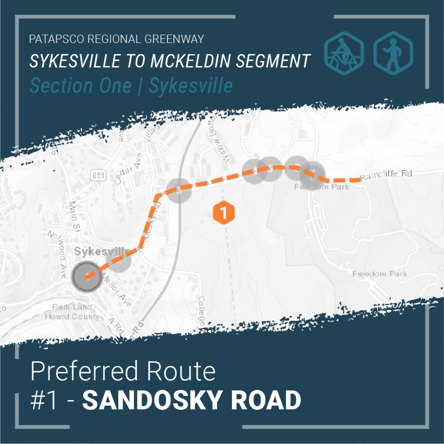 |
The western portion will connect downtown Sykesville shops, dining, and residences along Main Street to active and passive recreation opportunities in Freedom Park. This section of the trail is intended for low impact trail users such as walkers and cyclists and will consist primarily of paved shared use paths, on-road facilities, and a boardwalk structure along Sandosky Road.
Two alignment alternatives for Section 1 were considered during the public input period this spring. The design team considered public comments, steering committee comments, local advisory committee comments, and general design principles in identifying the Sandosky Road alignment as the preferred alignment.
The Sandosky Road alignment is a paved shared use path that travels from Main Street in downtown Sykesville, north along Sandosky Road, crossing MD 32 to Raincliffe Road and finally into Freedom Park via the Buttercup Road intersection.
|
|
Section 2 - Eastern Portion: Freedom Park to the McKeldin Area in Patapsco Valley State Park
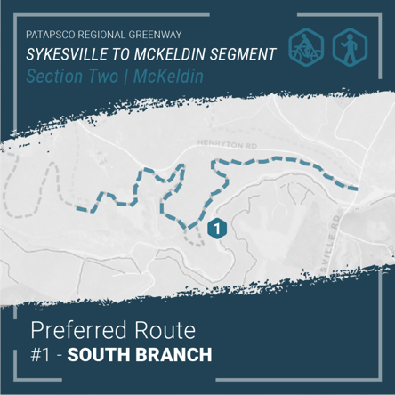 |
Users of this section of the trail will encounter dense forest, scenic views, ruins of abandoned structures, stream crossings, and many other points of interest. The design will highlight the natural and cultural wonders of the park, integrating high overlooks, rock formations, and archaeological treasures. The natural surface trail will serve hikers, mountain bikers, and equestrian riders with a sustainably constructed unpaved trail.
Similar to the western portion, the eastern portion considered two alignment alternatives through the Patapsco Valley State Park. The eastern portion of the multi-use trail will connect Freedom Park with the McKeldin Area of the Patapsco Valley State Park. Utilizing public comments, steering committee comments, advisory committee comments, and sound engineering judgement, the South Branch alignment was selected as the preferred alignment.
The South Branch alignment begins in Freedom Park and meanders through Patapsco Valley State Park towards the Heart of Maryland Bowhunters Club property. From there, the multi-use trail veers south towards the South Branch of the Patapsco River crossing over the historic Henryton rail tunnel, through the historic Henryton Sanitorium, paralleling Henryton Road and finally crossing Marriottsville Road before ending in the McKeldin area of the Patapsco Valley State Park.
|
To sign up for email notifications, click on the ‘Get Connected’ tab to the left.